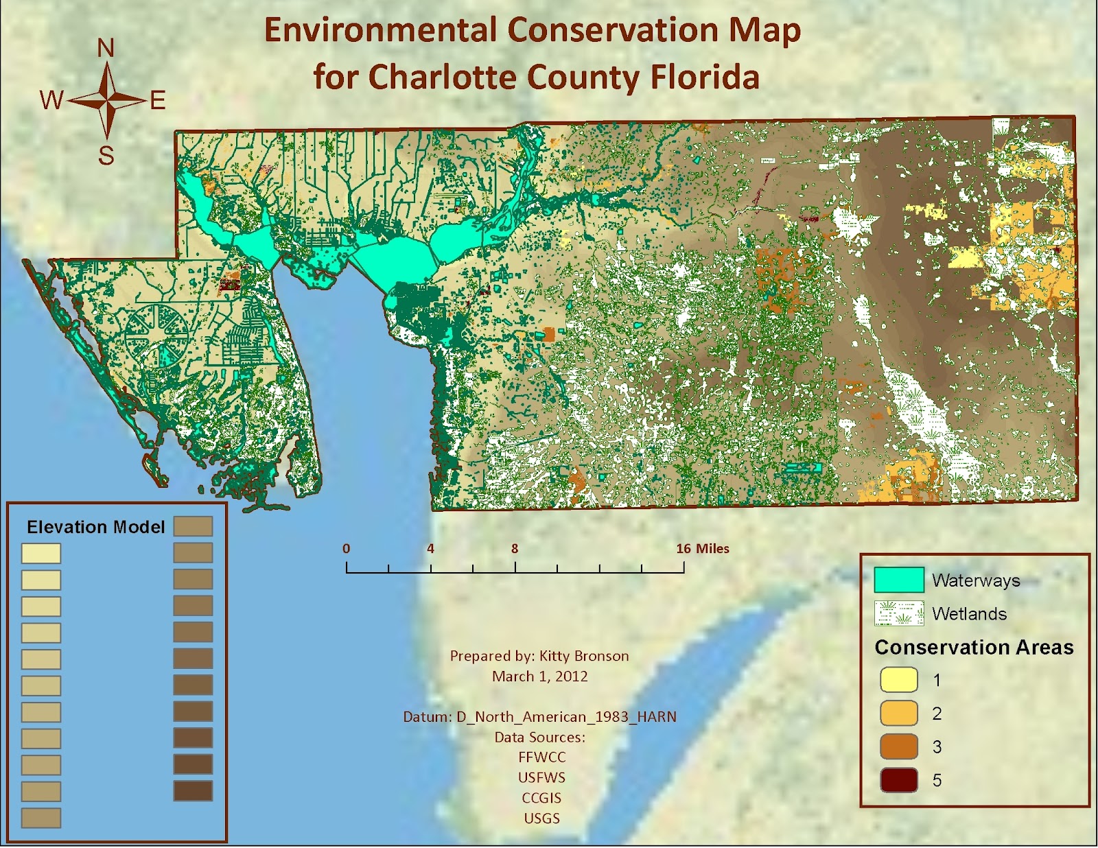
I really enjoyed working on the Environmental map and would have loved more time to do more with it. Once I started fresh and tried my new strategy it all came together really easily.
The Community Areas map was more frustrating and I am not very happy with it. Most of the layers came together pretty easily except the town layer I downloaded just did not work the way I thought it would, I didn't like it, it did not add to the information well so I deleted it. The roads layer did not work at all for me. I downloaded two separate layers, one of the layers we have worked with before and one that was the same projection/datum as some of my other layers like 'waterways' and from the same source and it still didn't work. By then I was out of time. I did find it interesting that all the community amenities, points of interest and parks were in one section of the county (the coast which makes sense) but there is almost nothing in the eastern part of the county.
As I did last week, I will be working on the map again during this weekend and figure out my problem before I jump into next week's assignment. I figure if I don't "get" where I am going wrong and keep moving through the assignments I will get to a place where I am truly behind and completely lost...so here goes some extra hours to fit in this weekend.

1) County boundary
o Source: FGDL
o Year:2011
§ File path: S:\DataSearch\Environmental\cntbnd_jun11
· Projection: Albers
· Datum: D_North_American_1983_HARN
· Units: Meters
2) Cities & Towns
o Source: CCGIS
o Year:
§ File path: S:\DataSearch\Community\Townships
· Projection:
· Datum: State Plane Florida West NAD83
· Units: Meters
3) Public land (Parks)
o Source: CCGIS
o Year:
§ File path: S:\DataSearch\Community\Parks
· Projection:
· Datum: State Plane Florida West NAD83
· Units: Meters
4) Public land (Points of Interest)
o Source: CCGIS
o Year:
§ File path: S:\DataSearch\PointsofInterest
· Projection:
· Datum: State Plane Florida West NAD83
· Units: Meters
5) Public land (Community Amenities)
o Source: CCGIS
o Year:
§ File path: S:\DataSearch\Community\Community_Amenities
· Projection:
· Datum: State Plane Florida West NAD83
· Units: Meters
6) Roads
o Source: CCGIS
o Year:
§ File path: S:\DataSearch\Streets
· Projection:
· Datum: State Plane Florida West NAD 83
· Units: Meters
7) Surface water (hydrography) Waterways
o Source: CCGIS
o Year:
§ File path: S:\DataSearch\Waterways
· Projection:
· Datum: State Plane Florida West NAD 83
· Units: Meters
8) [Environmental layer 1] Strategic Habitat Conservation Areas Priority Rankings
o Source: FFWCC (FGDL.org)
o Year: 2009
§ File path: S:\DataSearch\SHCA_PRIO_09
· Projection: Albers Conical Equal Area
· Datum: D_North_American_1983_HARN
· Units: Meters
9) [Environmental layer 2] National Wetlands Inventory for Florida
o Source: USFWS (FGDL.org)
o Year: 2011
§ File path: S:\DataSearch\NWIP_FEB11
· Projection: Albers Conical Equal Area
· Datum: D_North_American_1983_HARN
· Units: Meters
10) [Environmental layer 2] Soils
o Source: CCGIS
o Year: 1984
§ File path: S:\DataSearch\Environment\Soils
· Projection:
· Datum: State Plane Florida West NAD83
· Units: Meters
11) DOQQ
o Source: Labins.org
o Year:
§ File path: S:\DataSearch\Community\Aerials\q2415ne.sid (nw,se,sw)
§ File path: S:\DataSearch\Community\Aerials\q2415ne.sdw (nw,se,sw)
· Projection: Albers
· Datum: HPGN (NAD83)
· Units: Meters
· 2415 Bermont
12) DEM
o Source: USGS
o Year: 1984
§ File path: S:\DataSearch\Environment\DEM
· Projection: Albers Conical Equal Area
· Datum: D_North_American_1983_HARN
· Units: Meters
PART III: Process Summary Details
1) Added DEM file as layer
2) Added County boundary layer
3) Added Wetlands vector file as layer
4) Clipped DEM raster using ‘extract by mask’ tool to match county
5) Clipped Wetland vector using ‘clip’ tool to match county
6) Added Strategic Habitat Conservation Areas as layer
7) Clipped Strategic Habitat raster using ‘extract by mask’ tool to match county
8) Added Waterways polygon from CCGIS
9) Clipped Waterways to match county
10) Added essential elements
11) Saved and exported as S:\DataSearch\EnvironmentalMap_cmb.jpg
12) Added County Boundary to new map
13) Added Aerials for Bermont to layer
14) Added County Parks with reprojections to match boundary
15) Added Points of Interest layer with reprojections to match boundary
16) Added Water layer but it was to cluttered so took away.
17) Added Township Borders but that looked too cluttered, as well, so took away.
18) Added two different layers of roads but neither would show up no matter what I did, one wouldn’t show up at all, the other was out in the Atlantic.
19) Saved file and exported as S:\DataSearch\Community.jpg
No comments:
Post a Comment